July 15, 2026
Major culvert replacement work, including creek realignment, near 872 Huronia Road is complete. The next stage of culvert work near the Lockhart and Huronia intersection will start the week of July 20.
June 29, 2026
Major culvert replacement works and deep sanitary sewer installation are underway and are expected to continue until the end of January 2027.
Stage 2 of the work is expected to begin on July 2, 2026, with a full closure of the Huronia Road/Lockhart Road intersection through September 30, 2026. Detour routes will be in place and local access will be maintained where possible. Details are posted at barrie.ca/RoadClosures.
May 26, 2026
Hydro One will conduct pole installation and cable transfer operations at the Huronia/Lockhart intersection. The installation work is expected to be completed before June 1. Paid duty police officers will direct the traffic at the time of the utility relocations.
Major culvert replacement works and deep sanitary sewer installation are scheduled to begin on June 1 and are expected to continue until the end of January 2027. The City will post signage, as required, for detour routes. Various road closures will be required:
- Stage 1: Huronia Road, from south of Lockhart to McKay, will be fully closed to through traffic, with local access maintained for residents and businesses within the closure limits. This closure is expected to be in place from June 1 to September 30, 2026.
- Stage 2: The Huronia/Lockhart intersection is expected to be fully closed from July 2 to September 30, 2026.
- Stage 3: Huronia Road, from south of the National Pines Golf Club entrance to south of McKay, including the Huronia/McKay intersection, is expected to be fully closed from October 1, 2026 to January 31, 2027.
Details will be posted at barrie.ca/RoadClosures.
April 17, 2026
All tree removals were completed by April 1. Contractor is currently carrying out chipping operations along McKay Road near Highway 400.
The traffic bypass for the first stage of microtunnelling works is now in place. Signage is posted. Shaft excavations are expected to start in three weeks.
The next major stage of work will involve culvert installations on Huronia Road. Huronia Road, from Lockhart to the entrance of National Pines Golf Club (8165 Sideroad 10), is expected to be closed starting June 1. Details will be posted at barrie.ca/RoadClosures.
March 6, 2026
Tree removal works will take place over the next few weeks at the following locations and are anticipated to be completed by April 1:
- Huronia Road and McKay Road intersection
- Huronia Road and Lockhart Road intersection
- At and adjacent to 872 Huronia Road
- Highway 400 and McKay Road East intersection
Lane reductions may occur at times to accommodate the removal activities. Traffic control measures will be in place to guide motorists safely through the work areas.
March 3, 2026
Alectra plans to conduct line transfer works on Sunday, March 8. The intersection of Huronia Road and Lockhart Road will be fully closed from 8am to 6pm. Traffic control and detour signage are in place, and road closure and detour details are available at barrie.ca/RoadClosures.
The work was originally scheduled for March 1, but was rescheduled due to weather conditions.
February 27, 2026
The Huronia Road/Lockhart Road intersection closure scheduled for March 1 has been postponed. The new intersection closure details will be communicated once confirmed.
February 20, 2026
Alectra Utilities and its contractor require a full intersection closure at Huronia Road and Lockhart Road on March 1, 8am–6pm (weather permitting) for hydro pole relocation works. Advance detour signage will be in place. Road closure and detour details are available at barrie.ca/RoadClosures.
January 23, 2026
Condrain Group is planning to complete test pit operations on Huronia Road on Wednesday, January 28 (weather permitting). Temporary lane reductions are expected at times during this work. Appropriate traffic control and advance warning signage will be installed to inform residents and road users.
Alectra Utilities and its contractor require a full intersection closure at Huronia Road and Lockhart Road on February 9, 8am–4pm (weather permitting) for hydro pole relocation works. Advance detour signage will be in place. Road closure and detour details will be available at barrie.ca/RoadClosures.
The contractor will be on site to coordinate any temporary driveway disruptions or closures and will work to minimize impacts to nearby residents and businesses. We appreciate your patience and cooperation while this necessary work is completed.
January 12, 2026
Utility relocations on Huronia Road have reached another milestone. Vianet has completed all fibre relocations along Huronia Road and Lockhart Road.
Alectra will begin site preparation works during the week of January 12, 2026, at the Huronia Road and Lockhart Road intersection. Pole relocation work is expected to take approximately eight weeks.
Bell will continue its aerial cable transfer work along Huronia Road, progressing from north of McKay Road toward Lockhart Road.
December 15, 2025
Enbridge Gas has completed gas main relocations along Huronia Road and Lockhart Road.
Vianet Communication expects to complete the remaining fiber relocations by December 31, 2025.
Alectra Utilities is expected to start pole relocations mid-January 2026.
November 19, 2025
Enbridge Gas continues to carry out work on Lockhart Road at the Huronia Road intersection. Tie-in activities for Huronia Road are anticipated to occur in the coming weeks. The work will then shift to the west side of Huronia Road along Lockhart Road. All gas relocation work is expected to be completed by early December 2025.
October 23, 2025
An October 2025 info bulletin has been distributed to nearby properties. The contractor has retained the services of OZA Inspections Limited (OZA) to complete a precondition survey of the exterior and interior of all properties within the project limit. Residents should expect a letter from the City and OZA to book a pre-condition survey appointment.
October 15, 2025
Enbridge Gas civil works and pressure testing have been completed for the south part of Huronia Road. Enbridge’s contractor is now focusing on the remaining sections near the Huronia Road/Lockhart Road intersection, with full completion targeted by the end of November. Relocations for Bell Fiber Optic and Vianet Fiber Optic continue and are expected to be completed in November.
You can expect increased equipment mobilization along Huronia Road as the City’s contractor ramps up site activities. Project construction is expected to begin this month, with completion targeted for Spring 2028.
October 3, 2025
Utility relocation work continues to progress as scheduled.
- Bell Fiber Optic Relocation: Civil works haven been completed. Fiber splicing and cable pulling will follow. It is expected Bell's works will be fully completed in November.
- Vianet Fiber Optic Relocation: Remaining works on Huronia Road and south of McKay Road will be completed close to the end of October. The work is expected to be fully completed by mid-November.
- Enbridge Gas Relocation: Pressure testing is currently underway on Huronia Road and at the Huronia Road/McKay Road intersection, with completion targeted for mid-October. Following this, backfilling and removal of trench boxes will take place. You may hear a hissing noise during pressure testing; this is normal.
Gas relocation works will continue near the intersection of Huronia Road and Lockhart Road, with full completion targeted for the end of November.
August 1, 2025
Utility relocation work continues to progress as scheduled.
- Bell Fiber Optic Relocation: Civil works are expected to be completed by mid-August at Lockhart Road and Huronia Road, as well as McKay Road and Huronia Road. Fiber splicing will follow, with overall completion anticipated by December 2025.
- Vianet Fiber Optic Relocation: Work is expected to begin on August 4, starting south of McKay Road on Huronia Road. Completion is anticipated by end of September 2025.
- Enbridge Gas Relocation: Work is expected to begin in mid-August, with completion targeted for end of October 2025. During the Enbridge gas relocation, you may notice an odour like rotten eggs. This is normal and caused by an odourant used during the pipe installation process to detect leaks and ensure safety.
May 8, 2025
Utility relocations are progressing. K-Line Group of Companies has successfully completed hydro pole relocations along Huronia Road.
Next steps include:
- Bell Fiber Optic Relocations: Work is expected to begin in mid-May 2025 and continue through early July 2025 at multiple locations.
- Additional Utility Relocations: Other utility adjustments will also take place between May and July 2025. More details will be shared once the City received finalized schedules.
March 11, 2025
Increased construction-related activity is expected on Huronia Road, as K-Line Group of Companies has begun hydro pole relocations, on behalf of InnPower. This work is expected to be completed by mid-June 2025. Signage will be in place to assist motorists.
February 26, 2025
The City has retained EXP to conduct additional geotechnical investigations in the area. As part of this work, drilling activities have started and are expected to be completed the week of March 3, subject to weather and site conditions.
Residents can expect to see an increase in construction-related activity along Huronia Road, including the presence of drilling equipment and work crews. Every effort will be made to minimize disruptions, and appropriate safety measures will be in place throughout the duration of the work.
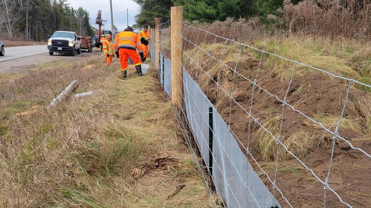
November 19, 2024
The installation of silt fences along Huronia Road has been successfully completed, marking a significant milestone in the project's progress. Current efforts have shifted toward the installation of highway fences and wire mesh, which are now the primary focus of the team. Notably, all posts for the highway fences have been fully installed, providing a solid foundation for the remaining work. With this substantial progress, it is anticipated that all fence installations will be completed by December 2024, aligning with the planned schedule.
September 11, 2024
The City awarded the wildlife exclusion fence contract to Anthony Furlano Construction Inc. The fencing will be installed along Huronia Road from Lockhart to McKay. The work is expected to start in mid-September 2024. Learn about wildlife exclusion fencing.
July 23, 2024
The turtle fence contract is out to bids and tenders and is anticipated to start in late August/early September 2024 and be completed by the end of this year.
The utility relocation designs are being finalized. Relocations are anticipated to start this fall and continue into 2025.
Additional geotechnical works are anticipated to be out to bids and tenders within the next week or so. The additional geotechnical field investigations are needed to obtain the MTO encroachment permits and finalize the microtunel designs. This work is anticipated to start in late September 2024 and be completed before the end of this year.
May 17, 2024
The tree removals along Huronia, Lockhart and McKay have been completed. As the removals extended beyond the March 31 environmental window, the City had Azimuth come to site to complete the necessary surveys to ensure no nests were present before removing the remaining trees. As per the City's Ecological Offsetting Policy, approximately $57,500 will be provided to plant new trees and landscaping within Barrie.
The LSRCA permit has been obtained and as such, the turtle fence tender will be posted before June 2024. The utility relocations are finalizing their design(s) and utility relocations are anticipated to commence in the summer.
March 4, 2024
- Lakeside Tree Experts are on site removing trees along the road in preparation of the utility relocation works that will be starting in the coming months.
- All property has been obtained for the project.
- Ainley has provided the turtle fence tender to the City and we are awaiting permits before beginning the work.
December 15, 2023
- The tree removal is anticipated to start early next year once the properties have been obtained for the road widening.
- The utility relocation designs are underway.
October 2, 2023
The tree removal is anticipated to commence in November. The turtle exclusion fencing tender is expected to be out for tender in mid-October.
August 3, 2023
The site preparation tender is under development. The utility coordination and property acquisitions continue to progress.
June 6, 2023
The site preparation tender is under development. The utility coordination and property acquisitions continue to progress.
May 1, 2023
The site preparation tender is under development. The utility coordination and property acquisitions are progressing.
March 2023
In February, the 100% detailed design package continued to be developed, and utility coordination and property acquisitions continued.
February 2023
In December and January, the site preparation tender submission was reviewed and comments were provided to Ainley. The 100% detailed design package remains under development, utility coordination remains underway, and property acquisitions remain underway.
December 2022
In November, the site preparation tender submission was provided to the City. The 100% detailed design package remains under development, utility coordination remains underway, property acquisitions remain underway.
November 2022
The 100% detailed design package remains under development, utility coordination remains underway, property acquisitions remain underway.
August 2022
- 100% Detailed Design package remains under development
- Utility Coordination is underway
- Property Acquisitions phase is initiated
June 2022
- 100% Detailed Design package remains under development
- Utility Coordination is underway
- Property Acquisitions phase is initiated
May 2022
- 100% Detailed Design package remains under development
- Subsurface Utility Deliverables provided
- Utility Coordination is underway
April 2022: 100% Detailed Design package remains under development.
March 2022: 100% Detailed Design package remains under development
February 2022: 100% Detailed Design package remains under development
January 2022: 100% Detailed Design package remains under development
December 2021: 100% Detailed Design package under development
November 2021: Ainley & Associates have provided the 90% design package that has been reviewed by the City. They are now working towards the tender submission.
October 2021: 90% Detailed Design package under development