March 12, 2026
Construction for the 2026 season is expected to start the week of March 16. A March 2026 info bulletin has been distributed to all affect residents.
North Rock Group is returning to site to continue construction on Albert Street, which will begin with installing new sanitary sewers and storm sewers. Residents may experience delays while travelling through the work site, but will be able to access their driveways.
December 16, 2025
Construction for the 2025 season is wrapping up.
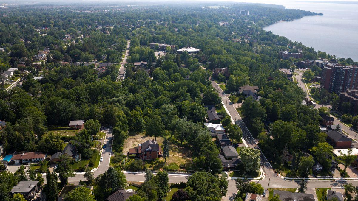
In 2025 the contractor reconstructed:
- Eugenia Street (Dundonald to St. Vincent)
- Worsley Street (Poyntz to Berczy)
- Berczy Street (Collier to Poyntz )
- Amelia Street (Berczy to end)
- Theresa Street (Berczy to Dundonald)
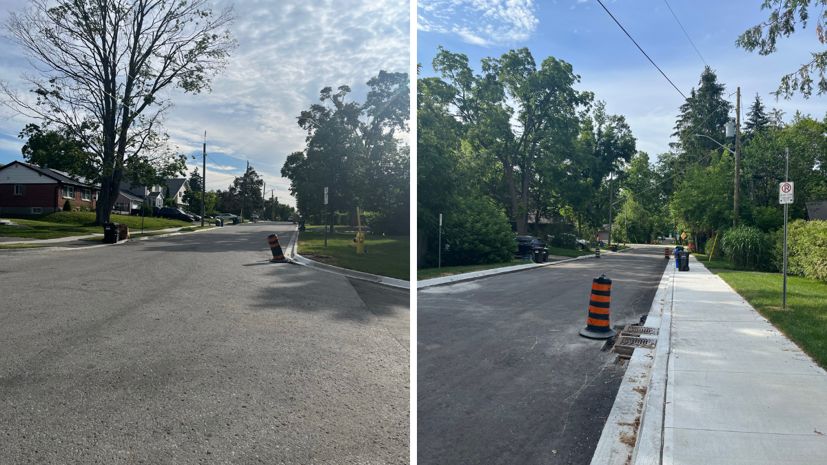
Work included, roadway reconstruction, watermain replacements, sanitary sewer replacements, storm sewer replacements, new curb installation, and new sidewalks on Eugenia Street, Berczy Street, and Theresa Street.
As winter weather arrived early in December, the contractor has used temporary asphalt on Theresa Street (Albert to Dundonald) including temporary asphalt on the driveways in this area. Over the next week the crews will tidy materials around the construction site.
The City is anticipating construction for 2026 to begin in mid-February (weather pending). An information bulletin will be issued to notify residents when the contractor plans to return.
Thank you to all residents for your support and cooperation throughout the duration of this project. We recognize the impact this work may have on your daily routines and appreciate your understanding and patience throughout the project.
We are distributing a December 2025 information bulletin to provide residents with and update on the progress of the project.
November 19, 2025
Work is progressing on Theresa Street.
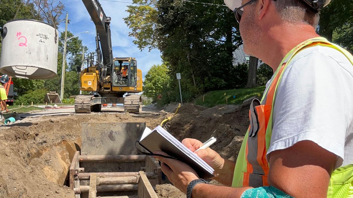
The contractor is nearing completion of the underground works for the 2025 construction season. Underground work is expected to be completed by November 28. Residents on Theresa Street can expect a short disruption of water service in the near future as services are switched to feed from a temporary watermain. Advanced notice will be provided.
The contractor is expecting to pour the remainder of the concrete curb and gutter on Theresa Street during the week of November 24. Residents will receive notices for driveway disruptions while the concrete is placed and cures.
The contractor plans to restore asphalt on Theresa Street for the winter months. The contractor will be cleaning up and taking a break prior to a holiday break. Work will resume in February 2026, weather pending. The City will provide notices to residents prior to the winter shut down, which will include updates on the project and remaining work.
Thank you for your continued patience while construction progresses. If you have questions or concerns, please reach out to the contacts on this page.
October 1, 2025
There are some concrete walkways and driveway edging to be restored on Eugenia Street. We expect this work to be completed by mid-October.
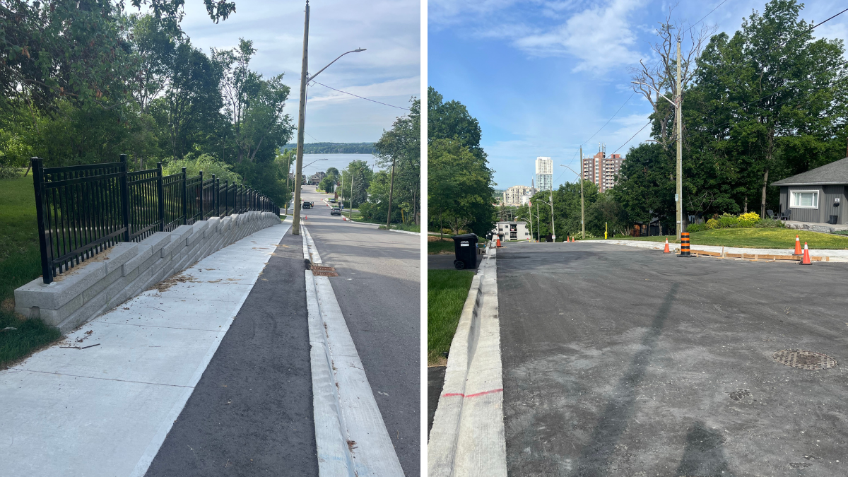
Construction of the new retaining walls on Berczy Street is ongoing.
Underground infrastructure installation on Theresa Street is continuing. Residents on Theresa Street can expect a short disruption of water service in the near future as services are switched to feed from a temporary watermain. Advanced notice will be provided.
Thank you for your continued patience while construction progresses. If you have questions or concerns, please reach out to the contacts on this page.
September 2, 2025
Interlock restoration on Eugenia Street, Dundonald Street and Albert Street are now completed. There are some concrete walkways and driveway edging to be restored, which are expected be completed by mid-October.
Concrete curb has now been placed on Berczy Street and Amelia Street dead end. The Contractor will be on site this week filling in some of the smaller curb sections.
Grading in preparation for asphalt paving will be occurring this week on Berczy Street and Amelia dead end. Asphalt base course is scheduled to be completed prior to September 19th, weather pending.
The replacement of underground sanitary sewer, storm sewer, and watermain is on-going on Theresa Street. Residents will experience temporary driveway disruptions, with advance notice provided.
If you have questions or concerns, please reach out to the contacts on this page.
July 30, 2025
Driveway restoration is complete on Eugenia Street, Dundonald Street and Albert Street. The contractor is continuing to restore interlock on these streets.
Sod has been placed on Eugenia Street. Residents are asked to be mindful of the new sod and to water as applicable to ensure the grass thrives.
Work to replace the underground infrastructure on Berczy Street is continuing. There will be disruptions to travel through the construction zone. We ask residents for their patience when travelling through.
The contractor is expected to begin replacing the underground infrastructure on the Amelia Street dead end off Berczy Street within the next two weeks. Residents on Amelia Street may have their driveway access restricted while these operations are ongoing. Residents will receive advanced notice.
July 11, 2025
Driveway restoration has begun on Eugenia Street, Dundonald Street, and Albert Street. Residents will continue to receive disruption notices as applicable.
Sod has been placed on Eugenia Street. We ask residents to be mindful of the new sod. Please do not cut the grass too short and please water as applicable to ensure the grass thrives.
Work to replace the underground infrastructure on Berczy Street is ongoing. There will be disruptions to travel through the construction zone. We ask residents for their patience when travelling through.
May 30, 2025
Sidewalk installation is beginning on Eugenia Street between Dundonald and St. Vincent. Driveway disruption notices have been distributed to affected residents. Residents with questions can reach out to the project team listed above.
The Collier Street & Berczy Street intersection continues to be closed while underground pipes and structures are being installed on Berczy. The intersection is expected to be opened to traffic by June 13. More road closure details are available at barrie.ca/RoadClosures.
We are expecting the first asphalt pavement layer to be placed on Eugenia Street and Worsley Street during the week of June 9.
City crews are also working in the area assessing and removing trees impacted by the ice storm. Learn more about this work at barrie.ca/IceStorm.
May 14, 2025
Work to install curbs along Eugenia Street from Dundonald to St. Vincent will be happening this week and next. Impacted residents will be notified. Boulevard restorations in the Eugenia area are ongoing. Paving on Eugenia and Worsley is expected to take place in early June.
The Collier Street & Berczy Street intersection continues to be closed while underground pipes and structures are being installed on Berczy. More road closure details are available at barrie.ca/RoadClosures.
City crews are also working in the area assessing and removing trees impacted by the ice storm. Learn more about this work at barrie.ca/IceStorm.
April 23, 2025
Reconstruction continues on Eugenia Street. Residents can expect a short interruption of water service during the week of April 28 to transfer water services from the old watermain to the new watermain. Notice will be provided prior to the transfers.
New sidewalk is being installed on Albert Street and Dundondald Street between Eugenia and Codrington. Driveway disruption notices will be provided to affected residents in advance.
The contractor will begin intermittent lane closures on St. Vincent Street at Duckworth as of April 24. The lane closures are expected to last for three weeks. Lane closures are required to install new watermain and water services, connecting to the previously completed work at St. Vincent and Duckworth.
If you have any questions or concerns, please reach out to the contacts listed on this page.
March 28, 2025
Reconstruction efforts are ongoing on Eugenia Street and Worsley Street. The work includes new sanitary and storm sewer, watermain, granular materials for road, curb and gutter, and concrete sidewalk.
Eugenia Street (Dundonald to St. Vincent) and Worsley Street (Poyntz to Berczy) are open to local traffic only. Residents may experience delays while travelling through the work site, but are able to access their driveways.
If you have any questions or concerns, please reach out to the contacts listed on this page.
February 24, 2025
North Rock Group is returning to site this week to continue construction on Eugenia Street, which will begin with installing new sanitary sewers.
Eugenia Street is set to be closed to through traffic between Dundonald and St. Vincent from today to spring 2025. Signage will be in place. Residents may experience delays while travelling through the work site, but will be able to access their driveways.
January 31, 2025
The contractor will resume work on Eugenia Street in February. Eugenia Street will be reduced to local traffic between Dundonald and St. Vincent. Please travel through the construction zone with caution. An updated information bulletin is being distributed to nearby residents.
December 18, 2024
The contractor has completed work for a winter shut down period. The City thanks residents for your continued support and cooperation this fall. The December 2024 Information Bulletin is being delivered to resident mailboxes to provide updates on the project.
The following restoration works have been completed:
- Base course asphalt was paved on Eugenia Street (Berczy Street to Dundonald), Dundonald Street (Codrington to Eugenia) and Albert Street (Codrington to Eugenia);
- New curbs were installed on Dundonald Street and Eugenia Street (east of Dundonald);
- A new sidewalk has been installed on Eugenia Street;
- Impacted driveways have been restored with asphalt; and
- Impacted grass has been restored with topsoil when adjacent to any sidewalk. Sod will be placed during the 2025 construction season.
The City anticipates construction for 2025 to begin in late January (weather pending). An information bulletin will be issued when an exact start date is anticipated. In 2025, construction will include underground installations, curb, sidewalk, boulevard restorations, and driveway paving, per the below schedule.
- Winter–Summer 2025: Eugenia Street (Dundonald to St. Vincent)
- Spring–Fall 2025: Albert Street (Theresa to Eugenia); Amelia Street (Albert to Dundonald) & (Berczy to End); Berczy Street (Collier to Poyntz); Theresa Street (Berczy to Dundonald); and Worsley Street (Poyntz to Berczy)
Top course paving on all roads in the project is expected to be completed in Summer 2026.
If you have any questions of concerns with the work, please contact the engineering contract administrator at craig.thompson@barrie.ca or 705-739-4220 x4667.
November 26, 2024
The contractor continues to reconstruct Eugenia Street and Dundonald Street. On Dundonald Street and Eugenia Street (east of Dundonald) the contractor plans to continue installing new concrete curb and gutter during the week of December 2, followed shortly by new base asphalt. Affected residents have been provided driveway disruption notices. Parking restrictions on adjacent roads will not be enforced during the driveway disruptions.
Residents on Dundonald Street and Eugenia Street (east of Dundonald) can expect a short-term water service disruption in the coming weeks to make the switch from the existing watermain to the newly installed watermain. Prior notice will be provided to all affected residents.
If there is snow accumulation before asphalt is placed on the road, the contractor will provide snow clearing on the roads only. Residents will still be responsible for their driveways and walkways.
The contractor plans to work on Eugenia Street until December 20, 2024. Below is what to expect during the winter period:
- The sidewalk on the north side of Eugenia Street (Berczy to Dundonald) will be placed, but it will be closed to pedestrians
- Base asphalt will be placed on Eugenia Street (Berczy Street to Dundonald), Dundonald Street (Codrington to Eugenia) and Albert Street (Codrington to Eugenia)
- Any disturbed driveways will be restored with asphalt
- Disturbed lawns will be restored with only topsoil over the winter and sod will be placed in spring 2025
- City of Barrie Operations will maintain the road for snow clearing
November 6, 2024
Codrington Street between Mulcaster Street and St. Vincent Street has been opened to traffic. North Rock Group will be placing new concrete curbs on Eugenia Street and Albert Street beginning November 7. Affected residents have been provided driveway disruption notices. Parking restrictions on adjacent roads will not be enforced during the driveway disruptions. Should you have any concerns with parking restrictions, please contact the project manager to discuss: jeff.henry@barrie.ca or 705-739-4220 x4592.
The contractor will be replacing aging watermain infrastructure within the intersection of nearby Penetang Street and Dundonald Street, which will be performed under this contract due to proximity. Access for residents and emergency services within the closure will be maintained. View all road closures at barrie.ca/RoadClosures.
October 11, 2024
A full road closure on Codrington Street between Mulcaster and St. Vincent is scheduled for October 15 to November 1, 2024. Access for residents and emergency services within the closure is to be maintained.
The closure is needed for the reconstruction of the Albert and Dundonald intersections. Works include the replacement of watermain, storm and sanitary sewers, and asphalt paving.
September 26, 2024
A full road closure on Codrington Street between Berczy and Dundonald is scheduled for Friday, September 27, 7am–7pm (weather permitting). Access for residents and emergency services within the closure is to be maintained. The road will be closed to buses. View the road closure map for detour details.
August 27, 2024
Work is underway. North Rock Group is installing new water valves to isolate the construction and minimize disruptions during the project. Construction of new sanitary sewer will begin on Eugenia Street this week between Berczy and Dundonald.
A full closure of Eugenia Street between Berczy and Dundonald is set to occur from September 3, 2024, to December 15, 2024. Construction timelines are subject to change based on weather conditions. View the road closure map for detour details.
North Rock Group will remove asphalt in the middle of the road. The road will temporarily be restored with gravel after the new sewer is installed. Residents can expect minor delays while travelling through site.
August 9, 2024
North Rock Group LTD has been awarded the contract and proposed a construction schedule:
- Overhanging tree branches will be removed from boulevard trees on project streets this summer through fall.
- In summer/fall 2024, construction will begin on Eugenia Street (Berczy to Dundonald), Albert Street (Eugenia to Codrington) and Dundonald Street (Eugenia to Codrington).
- In fall 2024, work is anticipated to begin on Eugenia Street (Dundonald to St. Vincent). This work will continue spring through fall 2025
- Construction for the Wellington D1 Neighbourhood Reconstruction Program roadways is scheduled to begin in spring 2025.
- In summer 2026, warranty repairs will be completed and the top layer of asphalt will be placed.
An August 2024 information bulletin has been distributed to affected residents.
June 2024
Design is 100% complete and the tendering of this contract is currently underway. Once a contractor has been retained, we will reach out to residents with information on the schedule. Minor pole relocations are currently being completed in preparation for the work.
September 2023
Design for both project areas are currently 90% complete. Tendering is expected this fall. Utility relocations are underway.
April 2023
Eugenia design is currently 60–90% complete. Design for the Wellington D1 neighbourhood reconstruction program is 90% complete. Tendering is expected later this summer. Utility relocations will begin in early summer.
June 2021
Eugenia design is currently 30-60% complete.